
BATTEN down the hatches and, if you must go out, reach for the wellies.
That was the essence of an updated Met Office weather forecast for Wellington, West Somerset, and Exmoor tonight and into the weekend.
The Met Office issued a yellow weather warning for heavy rain across the whole area from midnight Friday (November 17) until 10 am on Saturday.
A yellow warning means the rainfall could disrupt daily life with low lying land and some roads experiencing flooding, possibly causing delays for public transport.
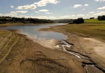 Environment Agency wishing for more heavy rain as rivers and reservoirs 'in recovery'
 Repairs to A396 Cutcombe Hill moved to nighttime work to avoid Snowdrop Valley clash
 Don't be caught out by festive changes to West Somerset recycling & waste collections
 Minehead X-ray department reopens as new equipment ready sooner than expected
Up to two inches (50 mm) of rain could fall in some areas, adding to the effects of a week where average rainfall has been higher than usual.
A Met Office spokesperson said the weather would become increasingly unsettled on Friday evening and the rain was expected to turn heavy at times during the early hours of Saturday, especially over Exmoor and high ground, while winds would strengthen.
However, temperatures were likely to rise through the night with a minimum of 7C.
Saturday would see a wet and windy start with outbreaks of rain gradually clearing through the morning and brighter spells should develop in the afternoon, although it would remain windy.
It would be a milder day on Saturday and the maximum temperature should reach 16 C.
The spokesperson said over the following few days it was likely the area would experience blustery showers, merging into longer spells of rain on Sunday and Monday, with some bright spells, but windy along the coast.
Meanwhile, the Environment Agency issued another round of flood alerts across much of Somerset.
It said flooding was possible and people should prepare for it, just in case.
One alert area was near Wellington where river levels were expected to rise overnight and flooding could occur from 7.30 am on Saturday along the River Tone from Clatworthy Reservoir to Currymoor, the Hillfarrance Brook, the Halsewater Stream, and other tributaries in the Tone catchment.
An Environment Agency spokesperson said: “We will continue to monitor the rainfall and river levels and our staff are checking flood defences and clearing weed screens.
“Avoid using low lying footpaths and roads near local watercourses and do not attempt to walk or drive through flood water.”
The Rivers Clyst and Culm, in Devon, were similarly expected to start flooding in the early hours of Saturday, affecting Hemyock, Culmstock, Uffculme, and other communities in the Culm Valley.
Pumping stations, including additional temporary pumps, were being used on the River Parrett to evacuate water away from the Parrett-Tone confluence, but areas around Steart, Stolford, Otterhampton, Stockland Bristol, Combwich, and Cannington were still considered at risk.
The agency said the Washford River was already high and the Horner Water, River Aller, Hawkcombe Stream, Monksilver Stream, and Doniford Stream would rise in response to the overnight rainfall.
Ity said it was looking at a flood alert area covering Horner Water, the Rivers Aller and Washford, and the Hawkcombe, Monksilver, and Doniford Streams and their tributaries.
On Exmoor, the main areas of concern were along the middle River Exe in Exebridge, Bolham, Bampton, and Tiverton, and in Dulverton, Brushford, Winsford, Exton, and Exford, where river levels suggested there would be flooding of low lying land and roads close to rivers.
The agency said it was monitoring the Rivers Haddeo, Batherm, and Lowman, the upper River Exe from Exford to Exebridge, and the Rivers Barle, Lyn, Mole, and Bray and their tributaries.
Comments
This article has no comments yet. Be the first to leave a comment.