

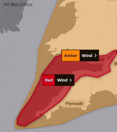
THE Met Office has now upgraded their severe weather warning for tomorrow (Friday) to red – the highest possible level – for Somerset, Cornwall, Devon, and South Wales.
The service’s weather warning map shows the red warning area as applying particularly to West Somerset, plus the north coast of Cornwall and Devon, and South Wales.
The Met Office website states: “Storm Eunice will cause significant disruption and dangerous conditions due to extremely strong winds on Friday.
“What to expect:


- Flying debris resulting in danger to life;
- Damage to buildings and homes, with roofs blown off and power lines brought down.
- Uprooted trees are likely.
- Roads, bridges and railway lines closed, with delays and cancellations to bus, train, ferry services and flights.
- Power cuts affecting other services, such as mobile phone coverage.
- Large waves and beach material being thrown onto coastal roads, seafronts and homes, including flooding of some coastal properties.
Before the storm:
• Secure loose objects such as ladders, garden furniture or anything else that could be blown into windows and other glazing and break them;
• Close and securely fasten doors and windows, particularly those on the windward side of the house, and especially large doors such as those on garages;
• Park vehicles in a garage, if available; otherwise keep them clear of buildings, trees, walls and fences;
• Close and secure loft trapdoors with bolts, particularly if roof pitch is less than 30°;
• If the house is fitted with storm shutters over the windows then ensure that these are closed and fastened;
• If chimney stacks are tall and in poor condition, move beds away from areas directly below them;
During the storm:
• Stay indoors as much as possible;
• If you do go out, try not to walk or shelter close to buildings and trees
• Keep away from the sheltered side of boundary walls and fences - if these structures fail, they will collapse on this side;
• Do not go outside to repair damage while the storm is in progress;
• If possible, enter and leave your house through doors in the sheltered side, closing them behind you;
• Open internal doors only as needed, and close them behind you;
• Take care when driving on exposed routes such as bridges, or high open roads, delay your journey or find alternative routes if possible;
• Slow down and be aware of side winds, particular care should be taken if you are towing or are a high sided vehicle;
• Do not drive unless your journey is really necessary,
After the storm:
• Be careful not to touch any electrical/telephone cables that have been blown down or are still hanging;
• Do not walk too close to walls, buildings and trees as they could have been weakened;
• Make sure that any vulnerable neighbours or relatives are safe and help them make arrangements for any repairs.
Meanwhile, in anticipation of significant high winds tomorrow, train company GWR is warning customers that they expect to cut services by half, the mainline in south Wales will be closed, and where long-distance trains can operate, journey times will be significantly longer.
As current forecasts suggest high winds will exceed 100mph, to make sure trains are able to run safely, speed restrictions across the Great Western Network are required.
This means GWR is expecting to significantly reduce the number of long-distance services, and where trains can run, journeys are expected to take much longer.
Some branch lines will have to close, and where bus replacement services are able to operate, they too will be affected by very poor road conditions, possible road closures, and are likely to be very busy.
The main line in South Wales will be closed with services terminating at Bristol Parkway,.
Disruption is likely to continue into the weekend as Network Rail works to check and clear debris and fallen trees over 1,000 miles of track.
To help customers, GWR is allowing people with tickets for travel on Friday, 18 February, to be able to travel today (Thursday) through to and including Monday 21 February.
GWR Managing Director Mark Hopwood said: “Speed restrictions will be put in place on our network, but the extent of those restrictions can only be determined by conditions on the ground and are likely to change throughout the day.
“We will continue to run as many trains as we can but those who need to travel travel should be aware that we will have to reduce the number of trains we can run, journey times will take longer, and those trains we can run will be much busier.
“Please do heed the usual advice to check before you travel, and if you hold a ticket for tomorrow [Friday 18 February] and would like to travel today or up to Monday, we have eased restrictions so that you are able to do so.”
The priority will be to keep trains running and customers moving safely, but changes to services are likely to be needed to allow that to happen and customers may wish to alter their plans.
Mike Gallop, Network Rail Western route and strategic operations director, said: “We’re working really closely with GWR and the other train companies to keep trains and passengers moving safely during this period of extreme weather.
“The severe weather associated with Storm Eunice is expected to bring significantly high winds of up to 100mph, and in places may result in trees and debris being blown onto train lines which blocks train movements and can cause delays and cancellations.
“Our operational colleagues will be out there on the front line braving the conditions to respond to any incidents and keep the railway clear and trains moving where it is safe and possible to do so.
“Storms can create a fast-moving picture so we’re asking passengers to please plan ahead and check before they travel.”
Those who choose not to travel at all will be able to claim a refund/allowed to amend their ticket. Those who travel and are delayed may be entitled to delay repay compensation if they are delayed by 15 mins or more.
Comments
This article has no comments yet. Be the first to leave a comment.