

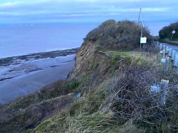
THE road from Watchet to Blue Anchor, threatened by landslips, could be saved by spending up to £32 million on its two major trouble-spots, according to a Somerset County Council-funded feasibility study.
The study was commissioned from Exeter-based engineering services experts WSP after the B3191 was closed at Cleeve Hill, Watchet, in December because of fears of a collapse through cliff erosion.
Six possible schemes to save that stretch of road have been considered, along with three for the cliff area next to the Blue Anchor Hotel, which has been closed due to land-slips.
WSP experts have called on the county council to carry out urgent research into funding, surveys and design programmes and to consult with stakeholders and the local community.

.jpeg?width=209&height=140&crop=209:145,smart&quality=75)
-with-Philip-Morgan-Summerfield-Homes-sales-and-marketing-director-.jpeg?width=209&height=140&crop=209:145,smart&quality=75)
The WSP report warns that if nothing is done, sections of the road at Cleeve Hill and Blue Anchor will be lost, seriously affecting local economic growth, development and regeneration, and making the area more isolated.
“Watchet has a high dependency on visitors and is dependent on good road and transport connectivity. The road infrastructure is therefore important to protect and grow the local economy,” it said.
The county council is legally obliged to maintain the public highway in a safe condition and the study looked at a range of options including doing nothing, new inland highway links and coastal and cliff stabilisation methods.
County councillors have been told that, with traffic increasing due to proposed planning development, the B3191 will play an increasingly important role between Watchet and Blue Anchor.
The study’s six alternatives for Cleeve Hill included a new 1.1 kilometre road across the former Wansbrough Paper Mill site towards the West Somerset Railway - costing up to £71 million- and a seven-kilometre road on top of a breakwater running from Watchet to Blue Anchor, enclosing a tidal lagoon and costing up to £1.2 billion.
The option recommended by the study, and costing up to £28.2 million, is a combination of coastal and highway measures, consisting of soil-nailing and mesh for the upper slopes opposite Saxon Close and rock revetment for the lower slope from West Street to Cleeve Hill.
“This would enable the road to remain in its current alignment along West Street and towards Saxon Close,” said the report. “The highway element of this preferred option is a diversion avoiding the section past Daws Castle and the Cleeve Hill failure.
“The cost for the highway element could be secured through adjacent development and limited funding may also be available based on preventing losses of some property and assets.
Comments
This article has no comments yet. Be the first to leave a comment.